Holderness Drain
Marfleet Lane
This information board stands a few miles north of the ancient hamlet of Marfleet, from which it takes its name. It is named as such because this was one of only two routes from Marfleet, near the banks of the Humber, northwards to Sutton village.
Holderness Drain locations
Marfleet Lane
This information board stands a few miles north of the ancient hamlet of Marfleet, from which it takes its name. It is named as such because this was one of only two routes from Marfleet, near the banks of the Humber, northwards to Sutton village.
Marfleet Lane had probably existed in one form or another for hundreds of years before the Holderness Drain cut across the lands here c.1832.
A drain much older than the Holderness Drain (of 1832), ran nearby – visible to the left of the Holderness Drain on the old maps. This was Bilton Drain, part of a system of field drainage possibly dating from the Middle Ages when drainage of this marshy area was begun by the larger monasteries in the area, such as Meaux Abbey near Sutton, but most likely dating from the late 1700s when the formal drainage boards were first formed.
This old Bilton Drain was culverted in the 20th Century, and the line of the ancient drain now runs under the back gardens of the houses in Winchester Avenue.
Mills and water-pumps
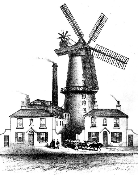
Wandering or riding around this area in the 1800s, the skyline would have been dotted with mills. Larger brick-built corn mills along the main Holderness Road, and the smaller sails of the water-pumps keeping the fields from flooding and the clay pits of the brickyards dry.
The nearby Four In Hand pub started life as part of a group of buildings belonging to a large corn mill on the Holderness Road.
Historic landscape
The mills, water-pumps, drainage and brickworks formed part of a working landscape shaped by agriculture and industry around Holderness Road.
Brickyards and house-building
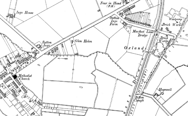
The brickyards were built around a large pit, where the clay was dug out of the ground to make bricks. The hand-made bricks were used to build the farms, mills, and later the houses in the area.
Although not built at the time of the 1850s map – by the time of the 1890 map there was at least one large brickworks accessed from this section of the Marfleet Lane.
The works would have been in constant use catering for the wave of house-building in the area in the late 1800s, and early 1900s.
The changing landscape
The whole length of Marfleet Lane at this north end had only two properties in the 1850s, both at the Holderness Road end; one named on the 1890s map as Sutton Ings Farm, and the other opposite, a very similar building, either a large comfortable private home or another farm.
By the time of the 1890s map the lane was completely built up on the north side with a long terrace of houses with large gardens, which survives today, and several smaller detached houses built later. Houses on the south side were built later in the 20th century.
Opposite the information board, at the entrance to the modern housing development of The Orchard, is one of the original detached Victorian houses, with an unusual roof line.
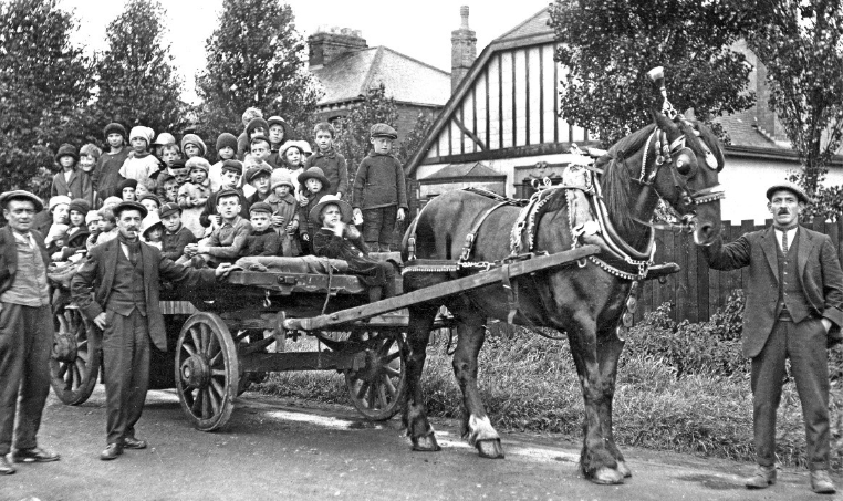
It can be seen in the photograph shown here, with a group of children out for a trip on a horse and rulley around 1910.
Children in this area would have had to travel by cart to school, either south to Marfleet, north to Sutton, or east to Bilton.
Changing landscape
Marfleet Lane
From an ancient route connecting Marfleet and Sutton, through the historic drainage landscape and past mills, water-pumps, brickyards and farms, Marfleet Lane has developed alongside the changing landscape of east Hull.
Explore Holderness Drain
Project Partners
Hull’s Dynamic Drains is led by the Environment Agency and delivered in partnership with Hull City Council , Groundwork Yorkshire and Yorkshire Wildlife Trust .
This information boards stands a few miles north of the ancient hamlet of Marfleet, from which it takes its name. It is named as such because this was one of only two routes from Marfleet, near the banks of the Humber, northwards to Sutton village. Marfleet Lane had probably existed in one form or another for hundreds of years before the Holderness Drain cut across the lands here c.1832.
A drain much older than the Holderness Drain (of 1832), ran nearby – visible to the left of the Holderness Drain on the old maps. This was Bilton Drain, part of a system of field drainage possibly dating from the Middle Ages when drainage of this marshy area was begun by the larger monasteries in the area, such as Meaux Abbey near Sutton, but most likely dating from the late 1700s when the formal drainage boards were first formed. This old Bilton Drain was culverted in the 20th Century, and the line of the ancient drain now runs under the back gardens of the houses in Winchester Avenue.
Wandering or riding around this area in the 1800s, the skyline would have been dotted with mills. Larger brick-built corn mills along the main Holderness Road, and the smaller sails of the water-pumps keeping the fields from flooding and the clay pits of the brickyards dry. The nearby Four In Hand pub started life as part of a group of buildings belonging to a large corn mill on the Holderness Road.
Hull Anti Mill, Marfleet
The brickyards were built around a large pit, where the clay was dug out of the ground to make bricks. The hand-made bricks were used to build the farms, mills, and later the houses in the area. Although not built at the time of the 1850s map – by the time of the 1890 map there was at least one large brickworks accessed from this section of the Marfeet Lane. The works would have been in constant use catering for the wave of house-building in the area in the late 1800s, and early 1900s.
Ordnance survey map from 1890
The whole length of Marfleet Lane at this north end had only two properties in the 1850s, both at the Holderness Road end; one named on the 1890s map as Sutton Ings Farm, and the other opposite, a very similar building, either a large comfortable private home or another farm. By the time of the 1890s map the lane was completely built up on the north side with a long terrace of houses with large gardens, which survives today, and several smaller detached houses built later. Houses on the south side were built later in the 20th century.
Opposite the information board, at the entrance to the modern housing development of The Orchard, is one of the original detached Victorian houses, with an unusual roof line. It can be seen in the photograph shown here, with a group of children out for a trip on a horse and rulley around 1910.
Children in this area would have had to travel by cart to school, either south to Marfleet, north to Sutton, or east to Bilton.