Maybury Road
Maybury Road was opened in 1925 by General Sir Henry Maybury, Director General of the Roads Department of the Ministry of Transport. It was named in his honour and formed part of the Outer Ring Road that was begun in 1924 to take traffic heading for the docks away from the city centre. The Outer Ring Road was not fully complete until 1937, when it was officially opened; it had cost £298,000 to build; the price of a single modern house.
Maybury Road – Holderness Road junction
The new Maybury Road also provided a more direct link between Ings Road and Marfleet Lane, avoiding the unusual ancient winding route of the much older Marfleet Lane, as seen on the c.1890 ordnance survey plan shown here. Note also – Hopewell Farm – from which the modern Hopewell Road took its name in the 1930s. Also visible on the 1890 plan (top left) Ings House, and Sutton Ings Farm, from which Ings Road took its name. ‘Ings’ is an Old English word that refers to water meadows and marshes, as before the drainage of this area the lands here were often flooded for much of the year.
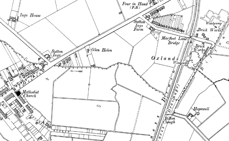
Ordnance Survey map 1890
On the right of the 1890 map you can see where the Bilton Drain ran into the Holderness Drain, at ‘Bilton Clough’. A ‘clough’ or ‘clow’ was a gate which could control the flow of the water into the larger drain but would restrict the flow backwards – to prevent flooding. The new Maybury Road was laid out to run from the Bilton Clough location in as direct a line as possible to Ings Road, where the Sutton Ings farm is shown on the 1890s map.
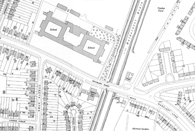
The increasing population around the Maybury Road area resulted in the construction of Maybury Road School, shown on the later 1946 ordnance survey plan here. This was opened for infants and juniors in 1934. A senior mixed department was added in 1935, which became boys only in 1937 and Maybury High School in 1945. The juniors became a separate department in 1937, and at reorganisation in 1969, both Primary and Junior High schools were created. The Junior High School was closed in 1988 leaving just the Maybury Primary School’ the old building was demolished and re-located to a purpose-built building away from the main road in 2007 and remains open in 2024.
Ordnance Survey map 1946
Another requirement for a growing population is obviously a pub. Maybury Road was no exception, and the Mayberry Pub opened in 1951, just to the left/east of this information board. Now long demolished, the site of the old pub is shown on the 1946 ordnance survey plan shown here.
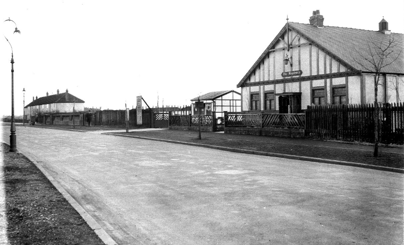
The old Maybury pub 1934
Streets on the east side of Maybury Road (except Harewood Avenue of c.1940) follow the Scots theme like those around Portobello Street, and Aberdeen Street, with names such as Cromarty, Hebrides, and Ronaldsway.
Streets on the south side all appear to relate to the theatre, music, and Broadway in New York, having names such as Majestic, Golden, Ziegfield, etc. Many of these streets were built on an old recreation ground. The unusual choice of names was probably due to the proximity of The Broadway housing development a little further west.
There is also new housing along Maybury Road, dating from the 21st Century, mingling with the original 1930s and 1940s housing along the main road.
Maybury Road was opened in 1925 by General Sir Henry Maybury, Director General of the Roads Department of the Ministry of Transport. It was named in his honour and formed part of the Outer Ring Road that was begun in 1924 to take traffic heading for the docks away from the city centre. The Outer Ring Road was not fully complete until 1937, when it was officially opened; it had cost £298,000 to build; the price of a single modern house.
Maybury Road – Holderness Road junction
The new Maybury Road also provided a more direct link between Ings Road and Marfleet Lane, avoiding the unusual ancient winding route of the much older Marfleet Lane, as seen on the c.1890 ordnance survey plan shown here. Note also – Hopewell Farm – from which the modern Hopewell Road took its name in the 1930s. Also visible on the 1890 plan (top left) Ings House, and Sutton Ings Farm, from which Ings Road took its name. ‘Ings’ is an Old English word that refers to water meadows and marshes, as before the drainage of this area the lands here were often flooded for much of the year.
Ordnance Survey map 1890
On the right of the 1890 map you can see where the Bilton Drain ran into the Holderness Drain, at ‘Bilton Clough’. A ‘clough’ or ‘clow’ was a gate which could control the flow of the water into the larger drain but would restrict the flow backwards – to prevent flooding. The new Maybury Road was laid out to run from the Bilton Clough location in as direct a line as possible to Ings Road, where the Sutton Ings farm is shown on the 1890s map.
The increasing population around the Maybury Road area resulted in the construction of Maybury Road School, shown on the later 1946 ordnance survey plan here. This was opened for infants and juniors in 1934. A senior mixed department was added in 1935, which became boys only in 1937 and Maybury High School in 1945. The juniors became a separate department in 1937, and at reorganisation in 1969, both Primary and Junior High schools were created. The Junior High School was closed in 1988 leaving just the Maybury Primary School’ the old building was demolished and re-located to a purpose-built building away from the main road in 2007 and remains open in 2024.
Ordnance Survey map 1946
Another requirement for a growing population is obviously a pub. Maybury Road was no exception, and the Mayberry Pub opened in 1951, just to the left/east of this information board. Now long demolished, the site of the old pub is shown on the 1946 ordnance survey plan shown here.
The old Maybury pub 1934
Streets on the east side of Maybury Road (except Harewood Avenue of c.1940) follow the Scots theme like those around Portobello Street, and Aberdeen Street, with names such as Cromarty, Hebrides, and Ronaldsway.
Streets on the south side all appear to relate to the theatre, music, and Broadway in New York, having names such as Majestic, Golden, Ziegfield, etc. Many of these streets were built on an old recreation ground. The unusual choice of names was probably due to the proximity of The Broadway housing development a little further west.
There is also new housing along Maybury Road, dating from the 21st Century, mingling with the original 1930s and 1940s housing along the main road.